Nerd's Travel Travel the World with Us!
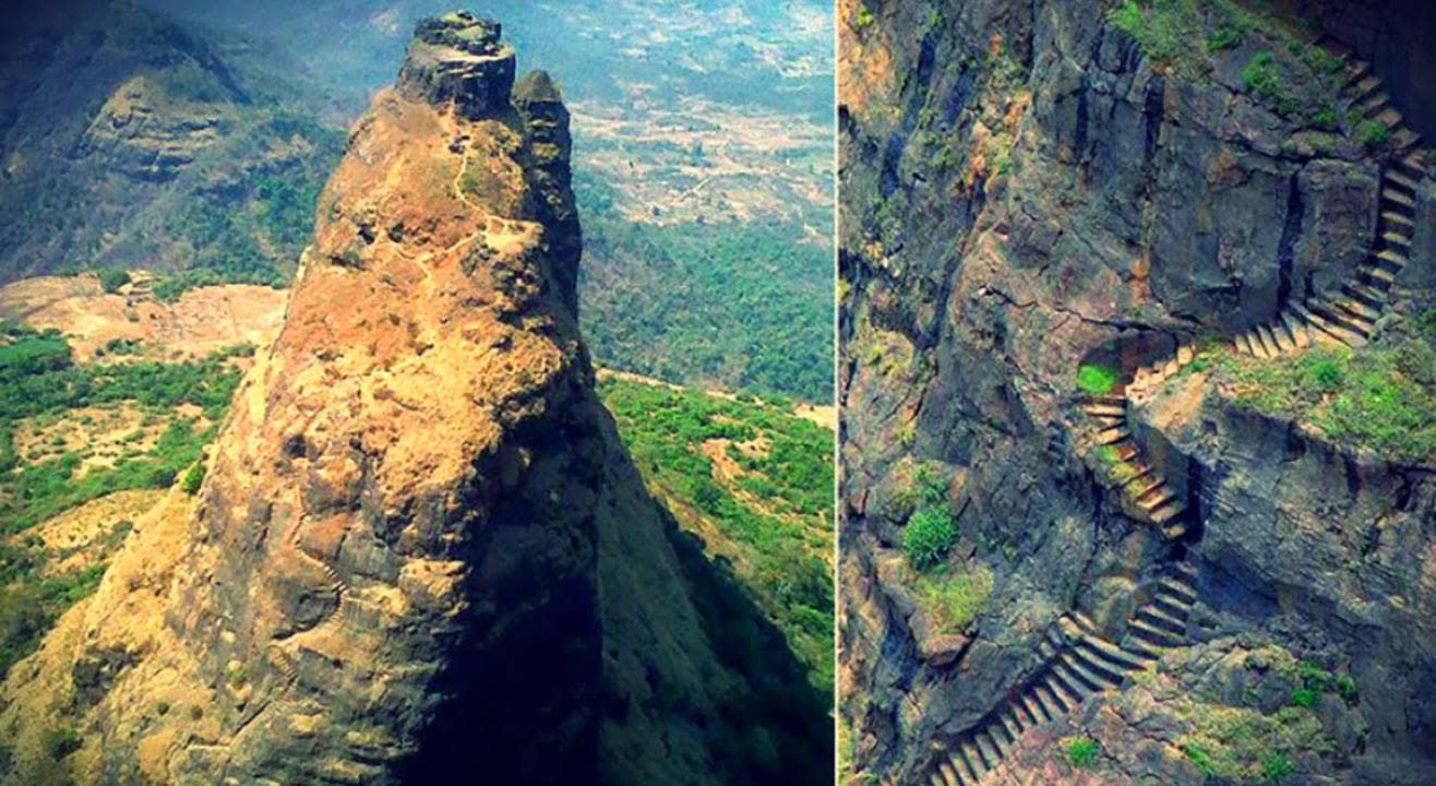
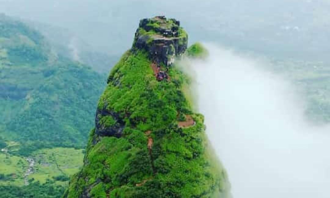
The Western Ghats close to Mumbai houses the world’s most dangerous fortress at the height of 701 meters that is about 2300 feet above the level of the sea. The Kalavantin Durg was fabricated to commemorate the memories of Queen Kalavantin. The fort offers a magnificent panoramic view of abundant natural beauty through the rugged terrain lands lined by the narrow rock-cutting steps. The steep slopes of the Kalavantin Durg have no support whatsoever, and taking a trekking trip to the fortress is dangerous yet ecstatic.
The Kalavantin Fort is touted as a “Climb to Heaven” because of the dangerous nature of trekking that it offers to its visitors along with the bird’s eye view of scintillating beauty of nature that awaits for the trekkers from atop.
Contents
A Trek to the world’s most dangerous fort
The base point of Kalavantin Fort is situated in Thakurwadi village, which leads the way to Prabalgad Fort and Kalavantin Durg. The trekking trip to the top of Kalavantin Durg will impart you with an adrenaline-spiking experience and will take a little more than 3 hours to reach the top. You can have access to climbing the fort through spiral stairs that are carved into the edgy rocks without any guard ropes or rails but contoured with swathes of scree.
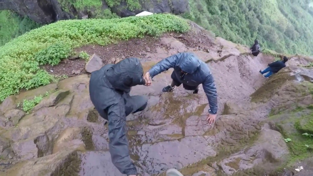
As you climb further, the trail starts to get steeper and induces vertigo on your way up. However, this doesn’t deter the zeal of adventure-seeking enthusiasts. All the adrenaline rush is definitely worth the gorgeous scenery and jaw-dropping views that you can experience from the top of the Kalavantin Durg. Towards the south of the fort, you can have a picture of minuscule waterfalls adding up to the view of the entire area. But, anyone with issues of vertigo shouldn’t plan on taking this trip.
View on the way to Kalavantin Durg
On your way towards the top of the Kalavantin Durg, you will find multiple “tea and snack” stalls lining the area. Also, there is a breakfast point that is located at Prabalmachi, which is the lowest-situated plateau perched at an altitude of 1279.5 feet. At this point, you can rest up a little and regain your energy for your hike ahead. Do not forget to fill up your water bottles and click some Instagram-worthy pictures to bombard your feed later. The stunning view of abundant greenery, virgin nature, and the alluring valley below can clench your heart with the thirst of purity and divinity.
After the breakfast point, the path starts to become quite abrupt, and if there is any rainfall, the level of risk faced automatically surges as the way becomes slippery. Thus, the trekkers need to cling to the roots of the trees and the rocks well enough to prevent putting their lives at risk. At some point, you will have to scramble up the steep slopes and over the rocks as well. Make sure to have a reasonable grip on the rocks when it starts to get windy.
What happens when you move past the Prabalmachi point?
When you move beyond the Prabalmachi plateau, the area seems similar to that of undulating terrain along with the rocky patches and cascading waterfalls gushing down the stairs. From this point, the trail starts to get even more treacherous until the pinnacle of the Kalavantin Durg. However, once you are taking in the bird’s eye view of the entire location from the highest point, you will forget all about the arduous ascent that you had to make. All you will do is soak in the enchanting view of the Western Ghats, Irshalgad, Peb, Chanderi Forts, Prabalgad, Matheran’s panoramic vista along with the city of Mumbai.
How to reach?
In order to reach the highest and most dangerous fort in the world –Kalavantin Durg, you will have to travel to Panvel in Mumbai, which is easily accessible via any kind of public transport and even private commuting services.
Nearest Railway Station: Harbour Line or Panvel Railway Station is the nearest railway station to Kalavantin Durg.
Nearest Airport: Chhatrapati Shivaji Maharaj International Airport, Mumbai, is the closest airport to Kalavantin Durg.
Location Map
If you think climbing up the steep slope of Kalavantin Durg was a problem, then you are not correct. The real challenge begins when you start descending the trail through the slippery terrain and boulders. You will have to climb down by following the narrow path leading towards the Prabalgad Fort, which is again another must-see location near the Kalavantin Durg. It will take you less than an hour to reach the stop. Although the gradient is steep, rocky, and tricky as well, you could fetch professional help to travel down the path safely. So what are you waiting for? If you are an adrenaline junkie, you shouldn’t miss visiting the Kalavantin Durg.